Satellite-Based Crop Health Analysis
Monitor crop health using satellite imagery and vegetation indices like NDVI, EVI, and RVI. Detect stress areas early and optimize resource usage for better yields.
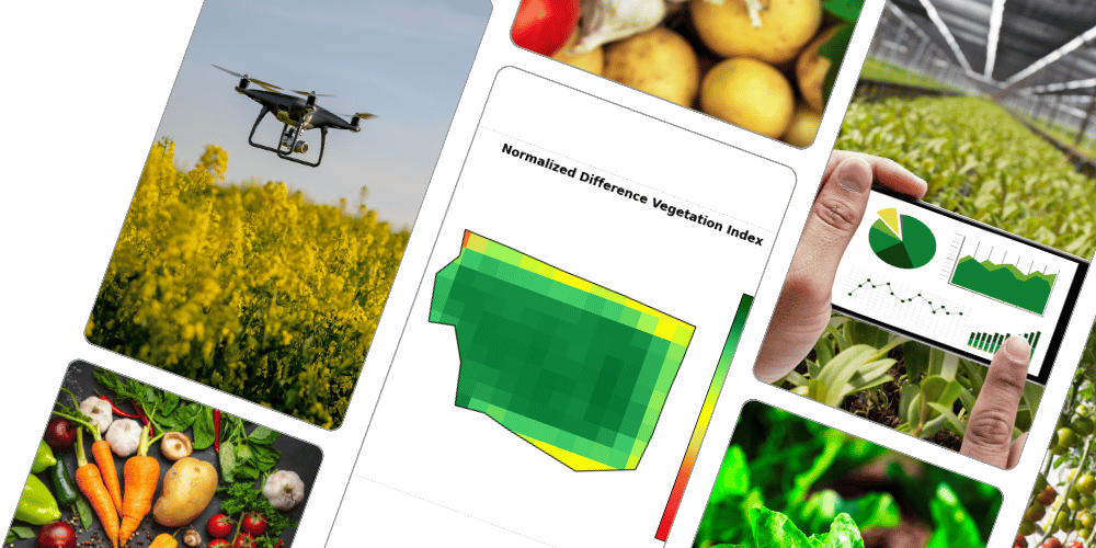
How the Service Works
KisanSAT leverages satellite imagery and advanced vegetation indices such as the Normalized Difference Vegetation Index (NDVI), Enhanced Vegetation Index (EVI), and Ratio Vegetation Index (RVI) to analyze crop health. These indicators help assess vegetation vigor, detect stress areas, and monitor overall plant growth.
By processing real-time and historical satellite data, KisanSAT identifies potential issues such as pest infestations, water stress, and nutrient deficiencies. The system then pinpoints affected areas, allowing farmers to focus on critical regions rather than conducting manual inspections of the entire field.
Benefits of the Service
Early Detection of Crop Stress: KisanSAT enables farmers to detect stress factors such as drought, disease, and nutrient deficiencies before visible symptoms appear, allowing for timely intervention.
Efficient Resource Management: Identifies specific areas that require attention, optimizing the use of water, fertilizers, and pesticides, reducing waste and costs.
Improved Yield and Productivity: Regular monitoring ensures that crops receive the necessary care at different growth stages, leading to improved yields and quality produce.
Time and Labor Savings: Instead of physically inspecting large fields, farmers receive precise data and insights, significantly reducing the time and effort required for field scouting.
Sustainable Farming Practices: Promotes sustainable agriculture by minimizing excessive chemical use and conserving water resources.
Procedure to Use KisanSAT
Registration: Farmers need to sign up on the KisanSAT platform using their credentials.
Field Mapping: Users input field coordinates or select their farm location from the satellite map available on the platform.
Satellite Data Processing: KisanSAT collects and analyzes satellite imagery, applying NDVI, EVI, RVI, and other indices to assess crop health.
Data Interpretation and Alerts: Farmers receive reports and alerts highlighting specific areas of concern in their fields.
Decision-Making and Action: Based on the analysis, farmers can take corrective actions such as adjusting irrigation, applying fertilizers, or deploying pest control measures.
Continuous Monitoring: Regular satellite updates help farmers track the progress of their crops and adjust management practices as needed.